Related Entries
Nikon Coolpix 2500: White Balance Gone Outdoors
Annotating photos with date
Wink
Button maker
The Century Project
« Coyote Linux
» WideStudio, DjVu
Earth view
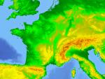 I came across a neat C program called EarthView:
Earthview produces a view or an image file output of an arbitrary region of the Earth, showing the elevation of lands and depth of oceans across the globe. It also supports other data sets such as the population density. The package only includes low-resolution samples, but earthview can make use of the GTOPO30 or ETOPO2 data sets, which have a resolution better than 1km on most land areas, and better than 4km in the oceans.
At the moment it works only on unix (needs X11 libraries to compile - which probably will work on Windows with some tweaking). It is a command line program, but it should be fairly simple to make a smal GUI wrapper around it.
I think this might be interesting later, because, the data can be packaged in CD or DVD and used from there. I’ve no idea what these GTOP and ETOP classificiations are, but may be this could work as a GIS-to-go system? ie, employees on the road , or business partners and analysts can be given a CD/DVD that they can use to look at various data geographically, when they don’t have connectivity to enterprise GIS systems?
GPS Drive - GPS software for Linux
GPSDrive is a car (bike, ship, plane) navigation system. GpsDrive displays your position provided from your NMEA capable GPS receiver on a zoomable map, the map file is autoselected depending of the position and prefered scale. Speech output is supported if the "festival" software is running. The maps are autoselected for best resolution depending of your position and can be downloaded from Internet. All Garmin GPS reveiver with a serial output should be usable, also other GPS receiver which supports NMEA protocol. GpsDrive is written in C with use of the GTK+ graphic toolkit and runs with Linux and FreeBSD.
graphics